As a remotely operated submersible rises from the deep ocean, a crowd of researchers rushes to the deck of the Nautilus to greet the exploratory machine's return.
It was a common scene when the Ocean Exploration Trust's 68-metre research vessel was far from Vancouver Island's shores for most of June, according to Moronke Harris, a science manager on the ship.
"Some people describe it as a paparazzi where all the scientists rush toward the vehicle and get their samples," Harris said.
The June expedition hosted several Greater Victoria scientists as they studied ecologically unique deep-sea sites that fall within Canada's newest and largest marine protection area (MPA).
In partnership with the Council of the Haida Nation, Nuu-chah-nulth Tribal Council, Pacheedaht First Nation and the Quatsino First Nation, the federal government designated the 133,000 square kilometres of ocean as the Tang. ɢwan-hacxwiqak-Tsig̱is MPA on July 11.
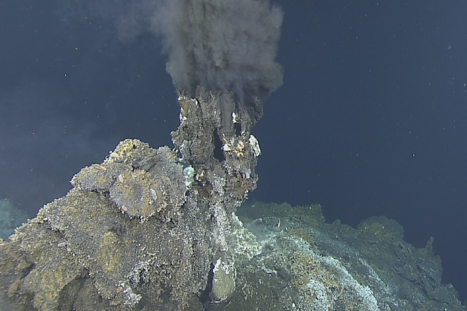
The aquatic zone located 150 kilometres off Vancouver Island hosts 47 underwater mountains known as seamounts and all of Canada's hydrothermal vents – which are super-heated black-smoking geysers formed by tectonic activity.
The expedition's researchers launched around 20 remotely operated vehicle (ROV) dives to the MPA's hotspots of geologic activity. The flurry of images taken by those submersibles will be stitched together to create three-dimensional models of the under-explored depths.
“Things change over the years – sometimes very rapidly and sometimes not so rapidly – and that affects all of the biological community in the region,” said Steve Mihaly, who was aboard the research vessel as a senior staff scientist with Ocean Networks Canada (ONC).
The Nautilus crew also used sonar technology to map the massive underwater structures and deployed autonomous devices that will record how seismic activity changes the seafloor over the next year. Those efforts will look at how seismic action is altering the deep-sea terrain, how nearby ecosystems are affected and if hydrothermal circulation may be changing.
Those factors are important to understand, Mihaly said, pointing to how it's possible those hydrothermal processes are linked to the origins of life.
“We have a strong sort of clue that maybe this is where life started and when it’s changing, that’s when we can see how new life can form,” Mihaly said.
As some of the giant chimney-like hydrothermal vents spewed out black smoke, the expedition captured footage that shows a vibrant community of animals inhabiting the areas. Those venting systems host some of Earth's highest levels of microbial diversity and they're a focus of Harris' research at the University of Victoria (UVic).
One of the highlights from the expedition for her was the ROVs recording a whale's skeleton sitting on the bottom of the ocean. A sunken carcass like that – known as a whalefall – becomes a nutrient-rich ecosystem for scavenging species as the deep-sea conditions slows the rate of decomposition.
Getting to study such skeletons are rare as scientists can't predict the resting places of dead whales. The expedition documenting the whalefall will help reveal how other species use the fallen whale remains, which will boost the overall understanding of deepwater environments, Harris said.
The researchers were also treated to a pod of humpback whales playing in their ship's wake for around an hour on the voyage's final day. For Harris, the contrasting events were a window into how the ocean circulates energy within itself and how whales sustain life throughout the water column across their life cycle.
“None of us had ever seen them come that close before or stay around for that long, so it was a really nice full circle moment and also contributes to just how important these ecosystems are," Harris said. “You got to see how this whale sustains all this life on the bottom of the ocean, but when it’s alive how it contributes to the ecosystem on the top of the ocean as well."
The expedition's main objective was to perform maintenance on Ocean Networks Canada's 800-kilometre-long NEPTUNE cable observatory, which relays a host of real-time ocean data.
That cable network runs through sites that are hundreds of kilometres off Vancouver Island and fall within the new marine protection area, such as the Endeavour hydrothermal vents, Cascadia Basin and Middle Valley. The remotely operated submersibles carefully mapping the dynamic seafloor at those and other spots during the June journey will help show what's going on in those seismically active areas.
“We now have a baseline with this mapping of the current structures and we’ll be able to see change going forward,” said Kate Moran, president of the UVic-hosted Ocean Networks Canada.
Those efforts to catalogue such a large swath of the ocean's depths are noteworthy amid a global push to map as much of Earth's seabed as possible by 2030, she said.
“We’ve mapped the moon and much of Mars but we still have not mapped the ocean, so this is all part of that (and) trying to understand our own planet,” Moran said.
The designation off B.C.'s coast also pushed Canada over the halfway point of its goal to protect 30 per cent of its ocean by 2030. The MPA – which has an area about four times the size of Vancouver Island – reaffirms bans on activities like bottom-contact fishing and oil and gas operations within its borders.
“It’s a big step forward,” Mihaly said, calling the MPA a major achievement for the Canadian government.
“The more we can understand these places we control through marine protection areas, the more we can control or advise how to use the rest of the seabed in a sustainable way."


