Every winter, the Ministry of Water, Land and Resource Stewardship releases monthly reports on the province’s snowpack levels. Data contained in these reports help experts predict if spring and summer could be tainted by flooding or droughts.
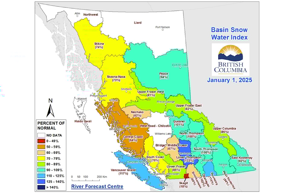
The latest figure for Jan. 1 determined that B.C.’s overall snowpack is “slightly below normal,” averaging 87 per cent of the normal level. Snow indices ranged from 18 per cent of normal in Skagit to 133 per cent in the Lower Thompson, with Vancouver Island standing at 117 per cent.
Although the overall snowpack is currently 13 per cent below normal, Jonathan Boyd, a hydrologist at the River Forecast Centre, said this figure is not worrisome in itself.
“For the most part, this season had actually kicked off to a pretty healthy start,” said Boyd. “It began with a combination of rain in September and October and some early storms in November.”
“December was kind of a mixed bag… and it started to get a little bit drier at the very end.”
According to Boyd, those below-average numbers are mainly due to January being drier than usual as a high-pressure ridge pushed storms further north towards the Alaska area.
“Typically January is the month where we get the greatest amount of snow accumulating and this year it's been pretty sparse, particularly in the interior,” said Boyd.
However, forecasts suggest the current dry trend will soon give way to wetter weather in February and March, Boyd added.
He estimated that two or three strong storms could bring levels back to or near the yearly average.
Although these predictions rely on advanced forecast models, meteorology remains a predictive science, noted Boyd. With early January marking the halfway point of the snow season, unexpected shifts in weather patterns over the next three months could significantly impact the province’s snowpacks, for better or worse.
“Every year is different and every month within the year is different.”
Too early to make a call, Boyd continues to monitor numbers across the province, awaiting the Feb. 1 snow report.
“At this point, we're primarily focusing on preparedness for the upcoming year,” said Boyd. “From the River Forecast Centre perspective… when the snowpack is very high, it means that my spring is very busy. When the snowpack is lower, it's a little bit easier from a flood perspective, but of course, the concern is then from the drought perspective.”
However, a deep snowpack does not always equate with higher flood risks, and vice versa, Boyd explained.
If spring months stay cool or warm up gradually, even a large snowpack can melt slowly without issues. However, a sudden heatwave in late spring can trigger drastic snow melts, increasing the risk of flooding.
Last year was a prime example of this unpredictability when provincial snow levels were nearly half of their expected average. January 2024’s report showed near-record lows at 44 per cent below normal, raising concerns among experts about potential impacts.
However, things took a positive turn.
“Last year it was unusual because the snowpack was so low but then we got really favourable weather conditions,” said Boyd. “March and early April were quite warm and we were worried about running out of the snowpack as early as ever before, but in late April, through June, it continued to be generally cool.”
Alternatively, scenarios can become bleaker. Boyd recalled that 2017 snow levels were “very low” as of Feb. 1, but rain and snow arrived later that month. That year, Okanagan Lake experienced significant flooding because preparations were initially focused on a potential drought. Instead, it turned out to be one of the wettest springs on record.
Although the future remains to be seen, Boyd and his team are preparing for what may be a drier summer.
“A lot can change, but right now we're trending toward a situation that is more hazardous from a drought or wildfire perspective.”


