While some British Columbians are simply enjoying the surge of hot weather that’s hit the province, much of the Interior is in emergency mode.
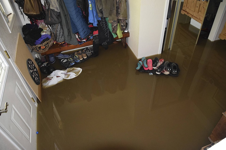
Flooding continues to be the cause behind more than 2,800 displaced residents in Grand Forks, Osoyoos with some on alert in Chilliwack.
Across B.C. there have been 32 evacuation orders affecting 1,993 homes have been issued and 36 evacuation alerts affecting 930 homes.
There are 23 states of local emergency, 10 band council resolutions and nine First Nations have emergency operations centres opened. Three reception centres have been opened for evacuees.
The regions hit with the most severe flooding:
Snowpacks continue to melt as temperatures are forecast to reach into the high 20s C this weekend.
In Grand Forks, Boundary rivers have reached and surpassed the highest levels since 1948.
WATCH: Volunteers pack thousands of sandbags as Grand Forks battles flooding
Officials there say river levels in the region have already started to receded, but that many evacuation orders will remain in place until a second surge of water from melting snow has passed through local watersheds.
That means a majority of those evacuated will have to wait until Sunday and into early next week, the regional district said.
Meanwhile, sandbagging continues in several locations across Grand Forks, and officials said Saturday will be spent prioritizing re-entry for homeowners who’s properties have been unaffected by flood waters for those that live between west Boundary and Christina Lake.
In Osoyoos, while the main lake has leveled out, according to officials, the waters still remain near record levels.
On Friday night, 30 more homes were evacuated. The initial 23 properties on Harbour Key Drive and Solana Key Court as well as the Coast Hotel in Osoyoos that were evacuated Thursday remain on Evacuation Order.
READ MORE: Fraser Valley in wait-and-see mode for flood risk from freshet
The City of Armstrong has issued an advanced evacuation alert as officials anticipate swelling along the Meighan Creek.
In Chilliwack, where the province continues to keep a close eye on Fraser River water levels, 20 homes are on an evacuation alert.
Public Safety Minister Mike Farnworth told media Friday that if the Lower Mainland does see flooding, it’ll most likely be into next week.
Public Safety Minister Mike Farnworth ahead of a conference on provincial response to flooding across B.C., speaking on the Lower Mainland levels: pic.twitter.com/vJuHBOjfQe
— Ashley Wadhwani (@ashwadhwani) May 11, 2018
Resources for evacuees:
All evacuees are urged to register with the Red Cross upon evacuation.
Grand Forks:
Emergency Operations Centre is 1-888-747-9119.
Emergency centres are located: Grands Forks Curling Centre at 7230 21st St., and the Midway Community Centre at 692 7th Ave., Midway.
Osoyoos:
All evacuees are being asked to register at the ESS Reception Centre, located at the Sonora Community Centre, 8505 68th St. Evacuees can register by phone at 250-490-4225.
Lower Mainland:
The province has activated the ESS Reception Centre in Surrey. More details will be supplied if an evacuation order comes into effect.
Learning the official flood terms:
Oftentimes officials will mark the severity of a flood with the term “one-in-90-year water levels,” or call it a “100-year flood.”
But what does that actually mean?
A 100-year flood, for example, has a one-in-100 chance of happening any given year.
Officials calculate the chance a flood event is expected to occur in a region by examining the floodplain in the area. The B.C. government, along with data from the federal government, has mapped floodplains on a 200-year basis here.
What is the province doing to help:
The province has so far supplied 10 sandbagging machines – including in Prince George and Kelowna – sandbags and 10 kilometres worth of Tiger Dams – also known as temporary dams.
“We work with local communities in terms of complimenting the work they are doing in their local area,” Public Safety Minister Mike Farnworth told Black Press Media.
There are currently 210 personnel assisting regional districts in regions seeing the most flooding, Farnworth said, with the option to deploy more aide as required.
The efforts of those individuals are in addition to the thousands of volunteers who can be found at sandbagging stations and search and rescue volunteers assisting emergency officials with rescues during evacuations.
My thanks to everyone who is working on this across the Interior, whether it be by opening your home to others, laying sandbags, working the lines in an emergency response centre or donating your pickup truck to carry sandbags to where they're needed. #BCFloods2018
— John Horgan (@jjhorgan) May 12, 2018
But much of what the province can offer – specifically funding – hasn’t been accessed yet, according to Farnworth.
During natural disasters like wildfires and flooding, cities across the province can apply for monetary assistance through B.C.’s emergency funding, which includes the Disaster Financial Assistance funding.
In addition to municipalities and districts, the funding is also open to homeowners, residential tenants, small business owners, charities and farmers.
If eligible, up to 80 per cent of disaster-related damages greater than $1,000 will be covered through the provincial funding, up to $300,000.
The province will also cover 100 per cent of the claims to local government to run emergency operations centres and will cover 80 per cent of costs to rebuilding or replacing essential public infrastructure that exceed $1,000.
Will the floods level? That’s a wait-and-see:
A lot of what comes next is a matter of wait-and-see, according to emergency officials.
As the weather remains warm, snowpacks that sat 150 per cent above normal levels continue to melt.
Only about five to 20 per cent of the snowpack has melted in higher elevations in the Southern Interior, compared with about 30 to 50 per cent of the snowpack in lower elevations.
Been 5 degrees above normal over past while. "Can be characterized as extreme weather," as it has been prolonged. Next week is third phase, "racking up a month of hot weather." 9,000 kL/s flowing through Fraser River.
— Dustin Godfrey 📰 (@dustinrgodfrey) May 11, 2018
READ MORE: B.C. officials watching for impact of ‘extreme’ heat on floods
The Okanagan region has been reduced from a flood warning to flood watch by the B.C. government, but that could change in short time as hot weather melts a heavy snowpack.
Meanwhile, the B.C. River Forecast Centre is watching for potential for flooding to “come back up again” on the already battered Boundary region.
Chris Duffy with Emergency Preparedness B.C.said Friday that hot weather expected to rise to the upper 20s C, and not dropping likely at least until mid-week next week, but potentially into the end of next week.
@ashwadhwani
ashley.wadhwani@bpdigital.ca
Like us on Facebook and follow us on Twitter.


