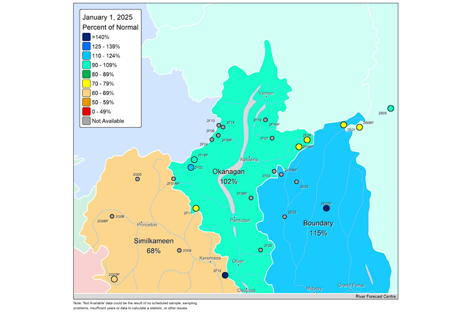
Folks on Vancouver Island, and in the Boundary area of the southern Interior are sitting on snowpacks notably higher than what is normal.
People across the rest of the province, not so much.
B.C.-wide, the snow pack was at 87 per cent of normal levels on Jan. 1 this year, which compares favourably with just 56 per cent on Jan. 1, 2024, but is not enough to alleviate concerns of summer drought.
The Snow Survey and Water Supply Bulletin is conducted by the province’s Ministry of Water, Land and Resource Stewardship and uses data from 40 manual snow courses and 113 automated snow weather services.
It's accompanying map features two regions comfortably in blue: Vancouver Island, at 117 percent of normal, up from 78 per cent last year, and the Boundary region, at 115 per cent of normal, up from 58 per cent.
The increases are in line with the overall B.C. trend, which was at 56 per cent at this time last year.
The area with the smallest base is the Skagit region, southwest of the Similkameen. It has a snow pack of 18 per cent of normal levels. But at least it is moving up; a year earlier, that region had zero per cent of its normal snow pack.
Of bigger concern is the province's northwest, home to the four areas where the snowpack has decreased this year. They are Stikine (from 96 per cent to 74), Skeena-Nass (from 80 to 73), Nechako (from 84 to 62), and the Central Coast (from 78 to 54).
In the southeast and south central portions of the province, the snow pack level has increased in all regions, including the Okanagan, where it is 102 per cent of the historical average, compared to 64 per cent of normal on Jan. 1, 2024.
The North Thompson and South Thompson regions are both at 100 per cent of normal levels, while the West Kootenay is at 94 per cent of normal and the East Kootenay is at 92 per cent of normal.
The South Coast is at 70 per cent normal, and the Lower Fraser at 85, up from 36 and 35, respectively. The Upper Fraser regions are a little over 80 per cent, and the Peace River area at 94, all higher than last year as well.
According to the ministry, snow accumulation in British Columbia was seasonally typical through November and December, with drier conditions in late December and continuing into early January.
Typically, nearly half of British Columbia’s annual snow pack accumulates by early January.
While British Columbia’s snow levels are lower than normal at present, conditions could change in the coming months.
“Areas with below normal snowpacks show early concerns for drought conditions amplifying in the spring and summer,” the report states. “With three or more months left for snow accumulation, seasonal snowpacks can still change significantly based on weather patterns through the remainder of the season.”
— with a file from John McKinley


