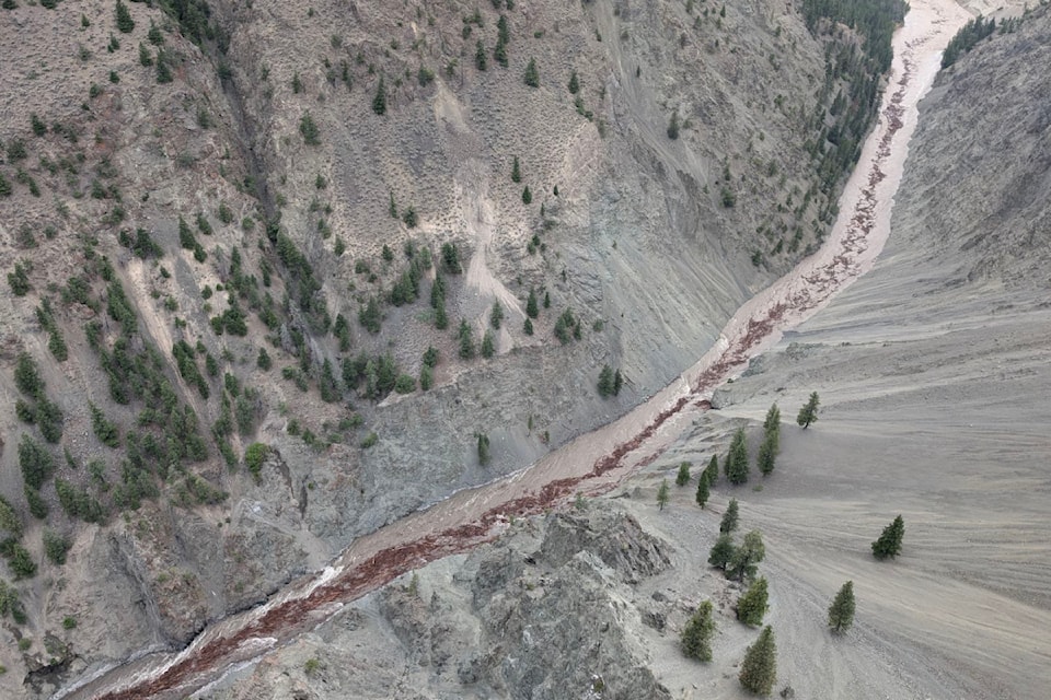
A pulse of high speed water carrying sediment and woody debris is making its way down the Chilcotin and Fraser rivers Monday (Aug. 5) after a landslide blocking the flow finally gave way.
Government officials say the water began pouring over the blockage southwest of Williams Lake around 9 a.m. and has been picking up speed every hour since. Emergency alerts have been issued for the length of the Chilcotin and Fraser rivers and people have been asked to evacuate the water and shorelines.
“I cannot underline enough how extremely unstable and dangerous the valley is right now," Minister of Emergency Management and Climate Readiness Bowinn Ma said Monday afternoon.
River banks are expected to erode both up and downstream of the breached blockage and Ma said there is a risk of further landslides being triggered.
B.C.'s executive director of water management Connie Chapman said as of 1:30 p.m. the lake built up behind the landslide was dropping at 1.3 metres per hour and the surge of water coming out of it was travelling at about 750 cubic metres per second. That's significantly faster than the river would normally run, although lower than is seen during the spring snowmelt.
Chapman said their modelling shows the river will be about 10.5 metres higher just downstream at the Farwell Canyon bridge, dropping to 7.5 metres higher at the confluence of the Chilcotin and Fraser rivers. It's also expected to reach its peak speed there, at a projected 8,273 cubic metres per second.
The surge is anticipated to hit the Lillooet area around 1:30 a.m. Tuesday, where it will elevate the Fraser River by about four metres. By 7:30 a.m. Tuesday, Chapman said Lytton will likely be impacted, with water an estimated 3.3 metres above normal. Boston Bar is expected to see river levels rise 2.6 metres by 11 a.m. Tuesday and Hope will see water rise about one metre by around 3:30 p.m.
At each point, the water will be flowing far faster and carrying far more debris than normal.
Margo Wagner, chair of the Cariboo Regional District, said they're expecting to see rocks, trees and mud carried downstream.
The landslide, which came down on July 31, was estimated to be 1,000 metres long, 600 metres wide and 30 metres deep. Beyond the sediment contained in that mass, Wagner and Ma said further erosion of river banks will deposit even more sediment into the now swiftly moving stream.
Ma emphasized that the most important thing people can do is stay away from the rivers.
"Now is not the time to go boating. Now is not the time to go take a look at the water."
In addition to the emergency alert covering the Chilcotin and Fraser rivers in general, some properties are also under evacuation alert or order. The province said 11 properties are under order in the Cariboo Regional District. A further one property is under alert there, in addition to four properties under alert in the Thompson-Nicola Regional District.
People have also been asked to stop flying drones over the landslide site as it interferes with the work of emergency responders. A NOTAM no-fly notice has been issued for an eight-kilometre radius around the area.
-With files from Monica Lamb-Yorski


