The B.C. government says a landslide currently damming the Chilcotin River is at risk of suddenly giving way and will release a dangerous mass of built up water and debris if it does.
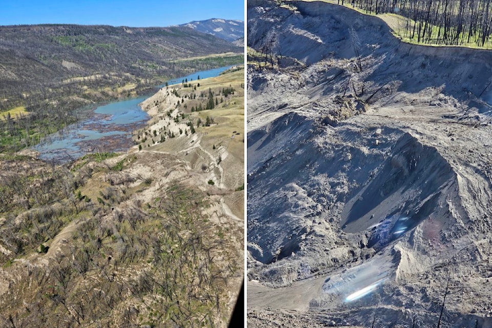
The slide, which rolled down and blocked the river south of Williams Lake overnight Tuesday, is estimated at 600 metres long and 30 metres deep. It's largely comprised of fine silts and clay, according to B.C. water management executive director Connie Chapman, and is highly susceptible to erosion.
Already, Chapman said, their experts on the ground have found evidence of some water leaking through the mass. The exact amount being held back isn't known, but Minister of Water, Land and Resource Stewardship Nathan Cullen said Thursday that the landslide has essentially created an eight-to-10-kilometre-long lake behind it.
If the landslide collapses, it will release a sudden surge of all that water and debris, putting anyone downstream along the Chilcotin River or connecting Fraser River at risk. The River Forecast Centre has issued a flood watch for areas around both rivers as far south as Hope. It has also issued a highstream flow advisory for the Fraser River from Hope to its exit into the ocean.
A flood warning is in place for the area of the Chilcotin River above the landslide.
READ ALSO: Chilcotin River rises 20 feet overnight upstream of landslide
Minister of Emergency Management and Climate Readiness Bowinn Ma asked all boaters to stay off the two rivers. She also urged anyone with a residence near the waterways to put together a grab-and-go bag and prepare their home for potential flooding. If the dam bursts, dozens more evacuation orders and alerts could be issued.
Ma said they estimate the water and debris would take 12 to 24 hours to reach Hope.
"Let me be clear, the risk to people and communities along the river is unknown at this time, but it has the potential to be significant."
Ma would not provide a timeline on when the landslide may give way, saying the situation is "dynamic and developing." However, Cariboo Regional District chair Margo Wagner told reporters Thursday that she had been informed it could be in the next 24 to 48 hours. She said the dammed water will either go over the top of the slide or break right through it.
READ ALSO: Flood warning, watch issued for Chilcotin and Fraser Rivers
Wagner also noted that the landslide came from a hillside that was burned in the 2017 wildfires.
"When lots of dead trees are there, nothing is there to absorb the water. This is a sandy area more likely to slip than others."
As of Thursday morning, the bridge at Hanceville that crosses the Chilcotin River upstream from the slide has been closed and ministry officials are monitoring both it and the bridge at Farwell Canyon which is about 20 kilometres downstream from the slide zone.
"We know many rely on the bridge crossings and First Nations have been on the lands for thousands of years," Wagner said.
Evacuation orders span 107 square kilometres along the Chilcotin and cover 13 homes, according to the regional district.
One person was injured in the landslide and rescued by local search and rescue members. Officials said Thursday that no one else has been reported missing or hurt.
They noted that the landslide will likely have impacts on the overall ecology of the river system as well. The area is a critical spawning habitat for many kinds of fish, including sockeye salmon, which are expected to arrive in the next couple of weeks.
"We are initiating early plans as to what we can do to make sure that those stocks remain intact," Ma said.


