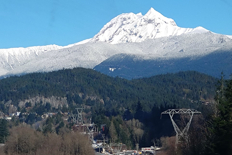
Had a person been standing in what is now the B.C. mountain town of Squamish on a day some 10,300 to 12,700 years ago, they would have been shocked to see a volcanic peak in the near distance roar to life and eject a fiery flow of viscous lava. Had they then chosen to stand in place instead of run, they would have witnessed that molten mass slowly spill down the mountain’s rocky slopes and flood through the valley below, pooling to an astounding 110 metres deep at its thickest point.
Today, we know that wall of lava eventually thinned and cooled until it came to rest 18.6 kilometres from its source, just back from the old Quest University campus on Squamish's eastern edge.
As far as volcanologists can tell, that was the last time Mount Garibaldi erupted. The volcano has now lain dormant for so long, many people – even those living at its feet – don’t know what it is capable of. And while recent explosions like that of Mount St. Helens in 1980 reminded British Columbians that such a cataclysmic event is possible, most are unaware it could happen even closer to home.
A large part of this knowledge gap comes from a serious underresourcing of volcanic research and monitoring in Canada. Even experts have limited information on the peak’s history and when it could become active again. What they do know is that of the 20-odd post-ice age volcanoes recognized in Canada, Mount Garibaldi is widely considered the highest risk. A present-day eruption could threaten thousands of people in Squamish, Whistler and surrounding First Nations, cut off transportation routes, destroy infrastructure, down power, flood valleys and ignite forest fires.
Oral history, volcanic debris point to peak's past
Information on the region's volcanic history is piecemeal, but some clues can be found in stories from the Squamish and Lil’wat Nations.
According to them, members of the two Nations once lived peacefully together in a village near the stratovolcano known as Black Tusk, today recognized as part of the Garibaldi Volcanic Belt. Problems grew between the groups as time went on, though, and they began to disrespect each other. Seeing this, a supernatural creature known as Thunderbird decided to teach them a lesson and flapped his wings until Black Tusk erupted. The explosion triggered a rock slide that buried the Nations' village and killed hundreds of people, forcing the survivors to work together once again.
Some place names also hold historical hints: In Sḵwx̱wú7mesh sníchim, the Squamish language, Mount Garibaldi is known as “Nch’ḵay̓." Translated to English, it means “dirty place” or “grimy one" and speaks to the tendency of the nearby Cheekye River to turn muddy in colour as a result of volcanic debris.
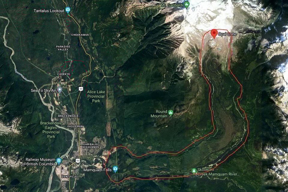
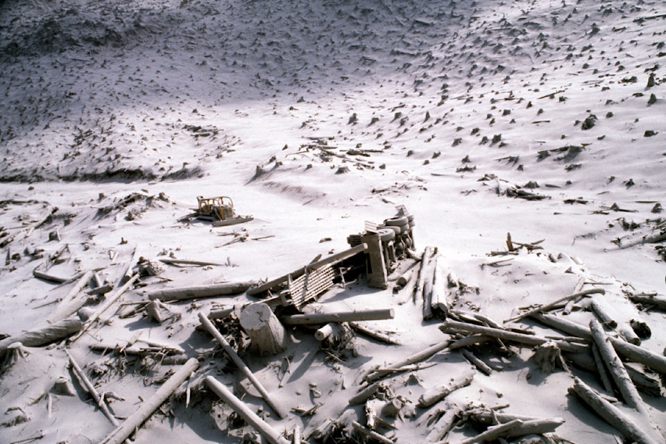
Other evidence of the area's explosive past comes from leftover rocks, charcoal and woody debris, as well as studying how the landscape has shifted through time. For instance, the last eruption out of Mount Garibaldi, the Ring Creek Lava Flow, displaced rivers and carved a path down to Squamish so clear it can easily be seen on a topographic map.
Conner Morison, a PhD researcher in volcanic hazards at the University of Edinburgh, has been analyzing those pieces of volcanic proof and trying to fill in knowledge gaps on Mount Garibaldi since he was an undergraduate in 2016. Morison said determining the probability of another eruption with any degree of accuracy is impossible, but that studying the area gives researchers a chance to unravel what has happened and what could occur in the future.
Lava far from the only potential threat
From his work, Morison has identified five major hazards that a future eruption may bring.
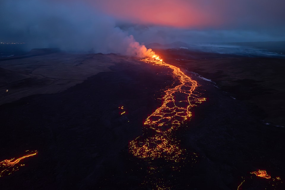
Perhaps the most obvious is lava. Ranging anywhere between 700 to 1,200 C, the boiling fluid is capable of flowing in waves tens of metres thick and incinerating everything in its path. Once hardened, it can bury homes, roadways and agricultural land.
Proof of its destructive power can be found in northwestern B.C. where lava beds stretch across the Nass Valley. There, a volcano known as the Tseax Cone erupted around 250 to 350 years ago and enveloped two Nisga'a First Nation's villages in lava, killing an estimated 2,000 people.
But in the case of Mount Garibaldi, Morison said lava would likely be the least of people's worries. Past eruptions there have produced relatively short lava flows between 6.4 and 18.6 kilometres long, with only the last one threatening the edge of what is now Squamish. Historically, those flows have also moved slowly, Morison said.
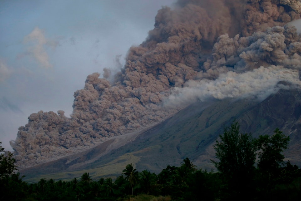
By contrast, something known as pyroclastic density currents move extremely fast. An explosive flow of scorching-hot pulverized rock and ash, the currents can travel down volcano slopes at hundreds of kilometres per hour and, depending on their force, stretch tens to hundreds of kilometres in length. Morison said suspected evidence of such events at Mount Garibaldi suggests past pyroclastic density currents have hit what is now the northern end of Squamish.
If it happened today, such a flow "could cause fatalities and impact critical infrastructure," Morison determined in a March 2023 paper published in the Canadian Journal of Earth Sciences. “Further expansion of Squamish as a commercial and residential hub will probably force infrastructure into even more susceptible terrain," he wrote.
Tephra fallout, or volcanic ash, is another major concern. During an explosion, a mass of ash and rock fragments is injected into the atmosphere, at first appearing as a kind of cloud above the mountain, before billowing out hundreds to thousands of kilometres away and falling to the ground. Morison said they haven't found evidence of tephra fallout at Mount Garibaldi, but that doesn't mean it hasn't happened. Melting glaciers means not everything that once surrounded the mountain remains.
If an explosion produced ash now, Morison said the thickest deposits could cause insulator flashover at power stations and lines, threatening electricity supply between Vancouver and Pemberton. It would also almost certainly cause traffic mayhem as it darkened the skies and settled on roads and runways. Even a thin dusting of ash could obscure drivers' and pilots' vision and cause skidding.
Back on the ground, slurries of liquefied volcanic debris known as lahars could wipe out people and infrastructure and dam waterways. Once the flows settle, they solidify like concrete and can cause major flooding. Morison said if a future Mount Garibaldi eruption mirrored those of the past, it is likely these muddy mixtures would pass through Squamish.
Around 2,300 to 2,500 years ago, an eruption at Garibaldi's neighbouring peak, Mount Meager, formed a 110-metre high block of solidified debris flow that dammed the Lillooet River. When the block finally collapsed, the sudden rupture released about 23 Olympic swimming pools worth of water and flooded valleys downstream as far as Pemberton.
Finally, the lava, fiery chunks of ash and scorching gases flowing out of a summer-time eruption would greatly heighten the risk of a large-scale wildfire – a consequence B.C. is largely familiar with.
No Canadian volcanoes regularly monitored
Despite all of this, the potential for fire, flood and destruction, Canada does not monitor Mount Garibaldi, nor almost any other possibly-active volcanoes. Even Mount Meager, one of the best-studied volcanoes in the country, is only monitored at a level in line with a "very low" threat rating, despite meeting the United States Geological Survey methodology standards for "very high."
Melanie Kelman, a volcanologist at the Geological Survey of Canada, compiled a threat assessment of 28 volcanic groupings in a paper published last February in the Canadian Journal of Earth Sciences and found both Mount Meager and Mount Garibaldi meet the "very high" threat threshold. She assessed three others to be a "high" threat, one to be of "moderate" threat, seven to be "low" and 15 to be "very low."
Besides Mount Meager, the only monitoring performed on those peaks is through regional seismic networks, in place to detect earthquakes broadly but not to pick up on subtle changes in volcanic activity. The U.S. Geological Survey recommends that very high risk volcanoes have real-time broadcasting and regular ground surveys and satellite imaging.
So, why doesn't Canada do this?
Kelman said it's largely a matter of money. With numerous natural disasters to consider across the country, it makes far more sense for governments to invest in preparedness for earthquakes, wildfires and floods rather than the rarity of a volcanic eruption.
“There’s an array of different hazards, all of which are important," Kelman recognized.
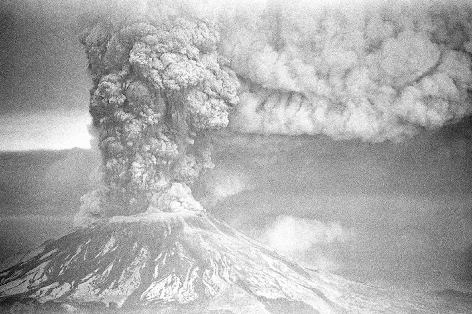
But, just because something is extremely rare, doesn't mean it can't happen. The U.S. learned that lesson in the spring of 1980 when Mount St. Helens erupted. At the time, only a single seismometer was in place to monitor the area.
The blast there was triggered when an earthquake cleaved off the upper 300 metres of the peak's northern cone and sent the largest landslide in recorded history tumbling down the mountain at 480 kilometres per hour. Ash shot 24 kilometres up into the sky, causing blackout conditions in Spokane, Washington and landing in 11 U.S. states and numerous Canadian provinces, including B.C.
Avalanches of debris and slurries of melted rock and ice poured down the volcano, clogging river valleys, destroying roads and bridges and ripping trees out of the earth. In the end, 57 people were killed and hundreds of homes and structures were ruined.
Volcanologists have since described the event as a wake-up call and turning point in understanding the need to study and watch even long-dormant volcanoes.
Today, activity at Mount St. Helens is constantly observed by 21 seismometers and a real-time gas monitoring system that checks for carbon dioxide, sulfur dioxide and hydrogen sulfide levels, as well as wind speeds and directions and the temperature of gas vents. GPS instruments installed along the volcano also let scientists know whether the ground is shifting over time.
Kelman said she hopes some of the same is implemented at very high-risk peaks like Mount Garibaldi and Mount Meager. While on-the-ground monitoring is pricey, she said remote monitoring through satellites would still provide valuable data on ground deformation, unusual gas emissions and new hot spots.
Morison, by contrast, said the focus needs to be on studying the peaks' histories, not just their current activity.
“The knowledge about when these volcanoes erupt, how they erupt, why they erupt comes from detailed fieldwork on the volcano first, before you start to monitor anything.”
Regardless of their priorities, both scientists agree volcanoes deserve greater attention in Canada. The chance of one awakening is low, but the consequences of such an event would be high.
And, while no amount of research will allow volcanologists to determine with certainty when another eruption could occur, it is their best shot at preparing for the future.
