While a time machine hasn’t been invented yet, there are other ways to journey into the past.
B.C.’s Ministry of Transportation features a page on the TranBC website called the “BC Road Trip Time Machine”, with links to more than 30 road trip reels from across the province, captured back in 1966.
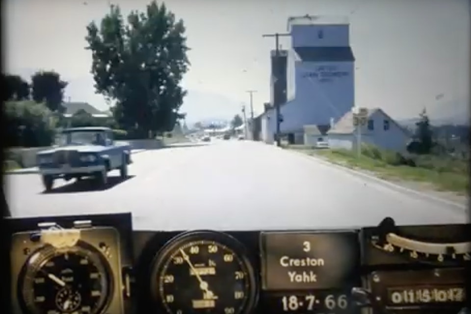
The captures aren't traditional videos, but rather "photologs" created from a sequence of still images taken by a camera mounted on a car's dashboard. The camera would snap a photo approximately every 80 feet while driving along the highway. The images were later compiled together to create a single film, creating an illusion of continuous motion.
The photologs were used to document road conditions across over 8,000 kilometres of highway throughout the province, allowing highway engineers to analyze specific sections without needing to visit them in person. As far as records show, the (formerly known) B.C. Highways Department was the first organization in Canada to gather information this way, creating a visual record of the province’s highways.
But not surprisingly, looking back on these 59-year-old reels reveals a lot more than just pavement condition. The camera caught sight of now long-forgotten landmarks and timeworn buildings, vintage vehicles that evoke nostalgia, and people from a bygone era, coming together in a vivid snapshot of the good old days.
A trip through time
One of the photologs takes a trip on Highway 3 from Princeton to the Alberta border.
According to the Ministry of Transportation, this route has seen many changes over time with standard safety improvements such as widened roadways, improved signage, installed barriers, additional turning lanes and exits, as well as more efficient connections between communities.
Along the way from Princeton, tiny villages like Cascade, Kinnaird, Kaleden, Tadanac, and Waneta were once significant enough to be used as directional start and end points to certain sections of highway. While some of these communities still exist, their importance as waymarkers has diminished.
In 1966, traffic had to pass through Salmo on the present-day Airport Road to travel west to Burnt Flat and Kootenay Pass. The mountainous stretch of highway between Salmo and Creston, originally called the Salmo-Creston Cut-off, was only two years old at the time these photos were taken. Before being dubbed Kootenay Pass, Dewdney Trail and Kootenay Skyway were also considered as names.
In photos of the drive through the Selkirk Mountains, at least five cars can be seen pulled over due to overheating on the steep climb. The Kootenay Pass has the highest point of elevation on Highway 3 at 1,774 metres (5,820 feet). And back in 1966, the highway was more commonly referred to as the Southern Trans-Provincial, reflecting its importance as a primary route in and out of the province. It stretches 1,161 km (721 mi) across the south from Hope to Medicine Hat, Alta.
It wasn’t until 1977, the entire stretch was officially named “Crowsnest Highway.”
As the video enters West Creston, it seems as if time has stood still over the decades. The roaming farmlands look as green and brimming with agricultural potential as ever. Entering the townsite, Creston’s two iconic grain elevators can be seen standing proudly on the right. Recently, the white elevator has been dismantled due to deterioration beyond repair. The red one, restored by Columbia Basin Trust, is one of only three wooden structures left in the province.
A plethora of amazing antique cars line the streets of downtown in the video, showing that Main Street has kept its charm over the years. The area is still very much recognizable to present day, other than the lack of traffic lights.
Leaving Creston towards Yahk, the bountiful orchard trees stretch as far as the eye can see. The time machine travels onwards through Cranbrook, Fernie, and to Crowsnest Pass. The photologs contain snapshots of the small towns, rivers, mountains, valleys, orchards, and lakes the Kootenays are famous for.
See more
To take a virtual vintage venture, visit www.tranbc.ca/tag/bc-road-trip-time-machine. Each trip posted on the website includes highway highlights and historical facts.
On YouTube, all 37 photologs have been digitized and are available to view on the BC Ministry of Transportation and Transit channel (see “BC Road Trip Time Machine” under Playlists).
Other road trips from 1966 include Nelson to Balfour on Highway 3A, the U.S. border to Vernon on Highway 97, Lytton to Revelstoke on Highway 1, and a fascinating journey from Horseshoe Bay to downtown Vancouver, showing a glimpse of the city and its people frozen in time decades ago.


