Ten new wildfire risk maps will help those living in more rural parts of the Capital Regional District understand their risks.
While wildfires are a natural process in fire ecosystems, they cause harm in communities, reads an Oct. 3 CRD statement announcing the maps for Juan de Fuca, Salt Spring Island and Southern Gulf Islands.
“Our communities are nestled in a rich natural environment with mixed forests and vegetation that have different levels of risk due to changes in stewardship and fire suppression practices over time,” said Paul Brent, chair of the electoral areas committee. “As we continue to live with climate change we need to work together with landowners and community partners to prevent and be prepared for wildfire.”
Hazard fuels – vegetation that throws embers or produces intense heat when burned – are a potential source of harm because they allow fire to spread quickly and put homes at risk.
READ ALSO: B.C. wildfires in 2023 scorch 3 million hectares
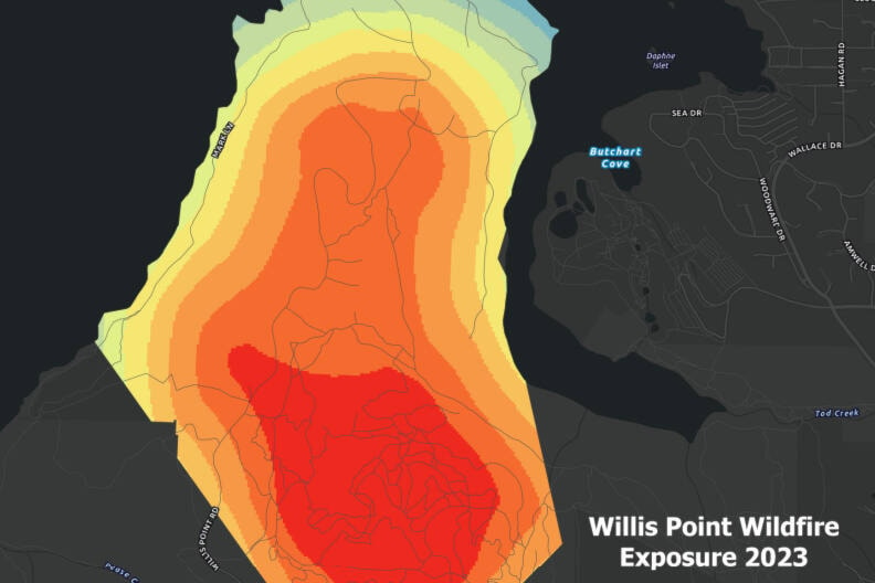
Exposure analysis measures hazard fuels within 500 metres of a point. The more fuels within that distance, the higher the risk.
The CRD and Islands Trust worked together to create the new wildfire exposure maps to support wildfire prevention and mitigation efforts across landowners. The Juan de Fuca mapping includes Port Renfrew, Shirley, Otter Point, East Sooke and Willis Point. Gulf Islands mapping includes Salt Spring, Galiano, Mayne, Pender and Saturna islands.
“If you find that you are in an area with high exposure, be prepared for wildfire. Take action to minimize risk on your property by following FireSmart recommendations and have an emergency plan ready,” Brent said.
“If you find that you are in an area with high exposure, be prepared for wildfire. Take action to minimize risk on your property by following FireSmart recommendations and have an emergency plan ready,” Brent said.
Damage from the 2023 B.C. wildfire season scorched more than three million hectares – more than twice as great as the fire damage from the second-worst season on record.
Find the maps at crd.bc.ca.


