Shortly before 6:30 p.m. on Monday, Aug. 11, 2025 a wildfire was reported from the Mount Underwood area southwest of Port Alberni, along the Bamfield Main Road.
In just a few hours, what started as a large puff of smoke raged to 630 hectares as a Rank 4 or 5 (out of 6), and at last count–just shy of a week later–it's 3,671 hectares, a wildfire of note and likely to keep burning for weeks.
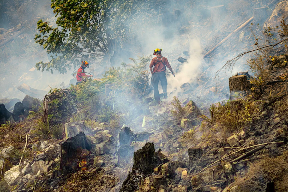
Seventy-two hours after the fire started, an incident command team with BC Wildfire Service took over, 87 firefighters were working on the fire, there were 14 with structural protection, 11 helicopters including two with night vision capabilities, 12 pieces of heavy equipment, 10 danger tree fallers and more. Aerial tankers were also attacking the fire in the first couple of days.
An evacuation order was issued and expanded by the Alberni-Clayoquot Regional District for China Creek Campground and about 50 businesses/ properties on Franklin River Road and Bamfield Main Road. Those roads remain closed between Port Alberni and Bamfield.
The City of Port Alberni declared a state of emergency and issued an evacuation alert along with the Tseshaht First Nation for Cameron Heights and Polly's Point, in case the wind shifted.
On Wednesday, an ominous pyrocumulus cloud could be seen towering over the fire site, and thick smoke began blanketing the city. A clean air centre was opened at the Alberni Valley Multiplex, and the First Nations Health Authority and nations in the region began issuing masks and air purifiers to people who needed them.
By Saturday, 33 millimetres of rain had fallen and the fire's behaviour changed. "The result of the rain has been that we've been able to get good, accurate mapping. We've been able to identify where the perimeter sits and get our crews real close to the fire," BCWS incident commander Stefan Hood said in a media briefing. "They're working primarily in the northwest to achieve our objectives of limiting spread towards our priority values."
Those priority values include the City of Port Alberni. Crews are also working on the south side of the fire to try to contain its spread in that direction as well.
"What we're not seeing is a return to the hot and dry conditions that resulted in the initial speed of this fire," Hood said. "The rain has quieted down the fire behaviour, we're mainly seeing just a smouldering ground fire.
"There are still some open flames out there and we continue to see that, but that's certainly a lot better than we had just a few days ago."
Hood said by Saturday the fire was displaying Rank 1 and Rank 2 behaviour. Rank one fires are smouldering ground fires without open flames that slowly spread. Rank 2 fires have small open flames and a slow rate of spread.
BC Hydro assesses damage, Bamfield without power
More than 500 residents of Bamfield, Anacla and Ditidaht First Nation have been without power since shortly after the Mount Underwood fire started. Representatives from BC Hydro on Friday were given the go-ahead to enter the fire zone and assess damage to power lines: 56 poles will need to be replaced, crews will need to restring 70 spans of power line–about 20 kilometres in total. A rebuild will cover six kilometres, according to BC Hydro, including two kilometres of "particularly difficult terrain marked by steep forested cliffs and unstable rock."
Nearly 80 personnel are working on the rebuild. Power restoration could take up to two weeks. For updates, visit www.bchydro.com/outages.
Telus sending mobile cell tower to Bamfield
The ACRD EOC reported on Sunday that Telus hasn't been able to restore cell service using "booster" technology so they are bringing in a mobile cell tower to restore service to Bamfield. The trailer-mounted unit should arrive on Wednesday or Thursday, according to the ACRD EOC.
Water restrictions in Port Alberni, Cherry Creek
The City of Port Alberni and ACRD on Friday implemented Stage 3 water restrictions. Last week Cherry Creek instituted Stage 4 water restrictions, all due to the Mount Underwood wildfire. Check the respective local government websites to determine what each stage means.
Wesley Ridge fire under control
It's hard to believe that the Mount Underwood fire is the second part of what B.C. Wildfire Service is calling the "Cameron Complex." Fire was discovered the night of July 31 at Cameron Lake on Wesley Ridge, across the lake from the site of the 2023 Cameron Bluffs wildfire that closed Highway 4.
The Wesley Ridge fire burned up the steep slopes and over the ridge, threatening Little Qualicum River Village and forced an evacuation order for hundreds of homes. That fire was listed as "being held" on the same day the Mount Underwood fire started.
This past weekend it was declared under control at 588 hectares. Wesley Ridge is approximately 19 kilometres from Mount Underwood as the crow flies, or in a straight line.
Check your sources
The Mount Underwood wildfire situation keeps changing, despite the welcome rain. Here are the best sources for information:
For up to date information on wildfires in the area or evacuation orders/ alerts, follow www.bcwildfire.ca or the BC Wildfire app.
For road conditions, follow www.DriveBC.ca.
The Alberni -Clayoquot Regional District's Emergency Operations Centre (EOC) posts regular updates as time allows at https://www.acrd.bc.ca/mount-underwood-wildfire and https://www.acrd.bc.ca/emergency-services.
Sign up for Voyent Alert to have alerts delivered to your phone/ inbox: www.acrd.bc.ca/voyentalert. Remember: alerts are made for those who need it, and Voyent Alert is for alerts – not updates.


